All posts by Emily Peterson

LandScope America: a tool to visualize land conservation

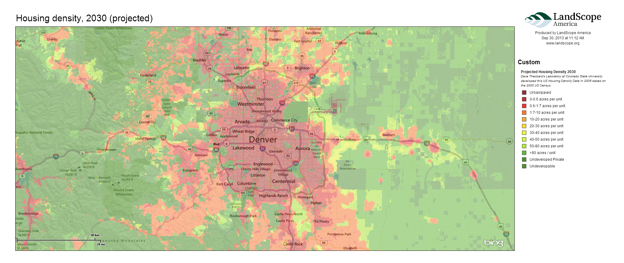
If you want to visualize your favorite wilderness area or map the protected areas in your city, LandScope America provides a free and convenient resource. This user-friendly GIS tool, a collaborative project of NatureServe and the National Geographic Society, lets you explore protected lands across the country, create maps of conservation projects, and share your work with others.

LandScope Screenshot

Key features of LandScope America

The focal point of LandScope America is an interactive map that overlays data layers, photos, and user-contributed stories. The map includes three key elements:

  • Base maps: three options (street, satellite, or hybrid) are found at the upper-right corner.
  • Themes: these comprise the spatial data that overlay the base map. Options include conservation priorities, protected areas, threats, plants and animals, and ecosystems. Users can change the theme by selecting the drop-down menu in the upper-left corner.

Diverse range of target audiences

One of the key advantages of LandScope America is its versatility for different user groups. Audiences that can benefit from the resource include:

  • Public agencies: In a recent post, we noted that $39 billion is spent annually on conservation in the United States. Public agencies could increase their effectiveness by combining the conservation priorities of public and private organizations in a single map layer. For example, agencies might overlay The Nature Conservancy’s ecoregional priorities with State Wildlife Action Plans and regional greenprints to better understand the level of coordination between various groups.
  • Land trusts: Using the mapping platform, land trusts can create, share, and print maps of conservation projects. For organizations on a tight budget, LandScope America can provide a powerful alternative to expensive GIS packages.
  • Private landowners: For farmers, ranchers, and private timberland owners, LandScope America features useful resources on options and financial incentives for conserving land. Using the map, landowners can see how their property fits into the wider ecological context and learn how providing wildlife habitat can make them eligible for incentive programs such as the Forest Land Enhancement Program.

Mapping in practice

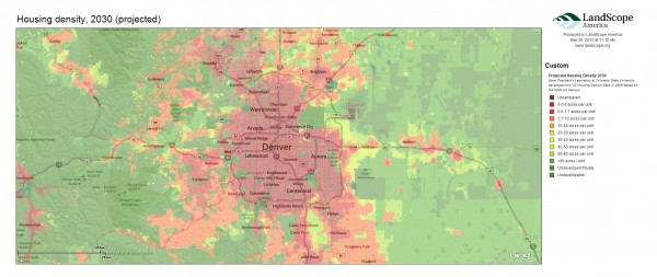
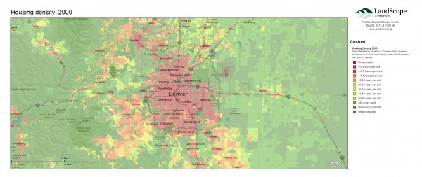
As an example, I mapped how changes in housing density around Denver relate to key wildlife habitat. The following three maps show the rapid rate of projected growth emanating from the city’s center.
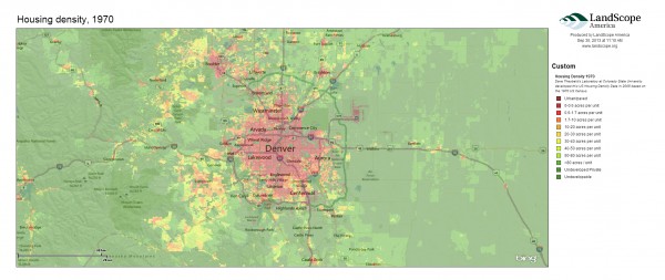
Denver_HousingDensity_1970
Denver_HousingDensity_2000
Denver_HousingDensity_2030
The next map shows important nesting areas and wildlife habitat in Colorado. Land trusts and public agencies could use similar maps to understand how projected human development may encroach upon habitat.
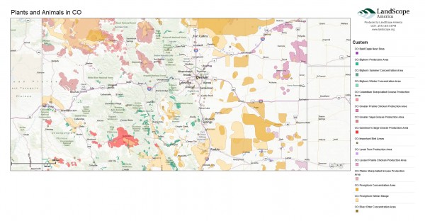
CO_State_Plants_Animals

Public expenditures in conservation

I also experimented with the map’s “Conservation by the Numbers” scorecards to examine trends in conservation spending across the West. This data is drawn from the Trust for Public Land’s Conservation Almanac, which tracks acres protected and dollars spent using public funding to buy land for parks and open space, during the time period 1998-2005.

Examining total spending on conservation, we see that California is the largest aggregate spender, with an annual average of $363 million spent on parks and open space protection. Wyoming has the lowest public expenditures, with $2.2 million spent annually on conservation funding. Montana has highest per capita public investments in conservation—roughly $179 per person. On the other end, Nevada spends only $13 per person on conservation. Below is an image from a dashboard we created to visualize the data.
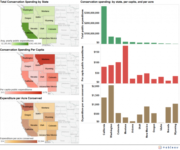
Conservation spending dashboardA wide variety of factors, however, influence the cost of protecting land in a given state. In Washington, it costs an average of $2,044 to conserve an acre of land, but only $14 per acre conserved in Idaho. Several variables could explain this wide gap, including differences in land prices and development pressures. Washington’s high costs may also reflect some high-value acquisitions during the period in question.

Explore beyond your backyard, both near and far

LandScope America also lets you discover and explore open spaces near your own home. Just enter a zip code to find parks and nature preserves, as well as the names of conservation organizations working in the area.

In addition, LandScope America exposes users to more remote wilderness areas through photographs, audio, video, and articles embedded directly in the maps.

Explore your favorite places in the West using LandScope America, and let us know what you learn.

Downloads

EcoWest’s mission is to analyze, visualize, and share data on environmental trends in the North American West. Please subscribe to our RSS feed, opt-in for email updates, follow us on Twitter, or like us on Facebook.

Q&A: Financing land conservation in the West

EcoWest recently had an opportunity to speak with Dee Frankfourth, Associate National Conservation Finance Director at The Trust for Public Land (TPL) and Eleanor Morris, Senior Policy Representative at The Nature Conservancy (TNC). We interviewed Frankfourth and Morris about trends they are observing in their conservation finance work to protect open space across the West.

 Both TNC and TPL, along with local land trusts and other partners, secure public funding for conservation in the West and elsewhere through open space ballots and legislative initiatives.

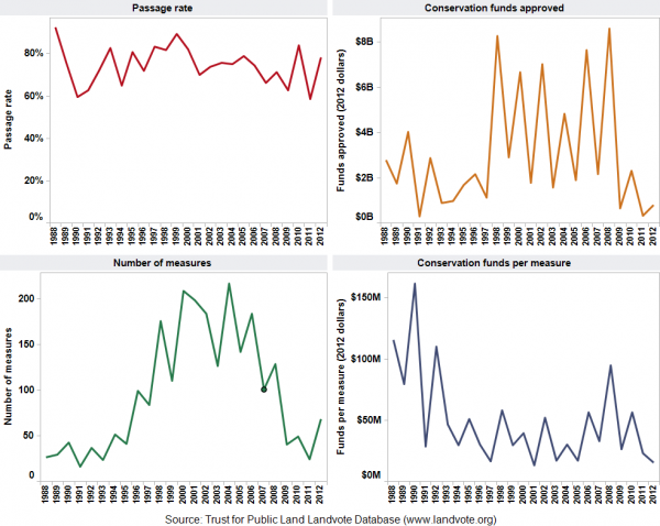
Conservation finance initiatives occur in two ways. First, the public can vote directly on a ballot measure to approve a new funding source (e.g., a bond, income tax, property tax, oil and gas revenues, or lottery proceeds). Second, legislatures can approve funding through a budget line item or general fund appropriation. You can learn more about conservation finance initiatives in this EcoWest post or on this dashboard (click the screen shot below to enlarge).

Ballot measure dashboardBelow is an edited Q&A with Frankfourth and Morris.

EcoWest: Can you highlight any conservation finance initiatives that have recently passed in the West?

Dee Frankfourth (TPL): Most measures in the West occurred in their primaries during May and August of this year, including:

  • Blaine County, Idaho: This county, located near Sun Valley, passed a $3.5 million property tax to reconstruct the 20-mile Wood River recreational trail. This is actually quite a significant amount for a rural county, and it passed overwhelmingly, with 83 percent approval.
  • Portland, Oregon: With 54% of the vote, the metro area of Portland that includes parts of three counties passed a $50 million property tax for stewardship of lands acquired during two previous bond measures, and to fund other open space acquisitions.
  • King County, Washington: This county surrounding Seattle, the 17th largest in the nation,  passed by 70% a six-year property tax that will start at $60 million in the first year and increase annually. The measure will help keep county parks and trails in good condition and also provide funding to protect new open spaces.

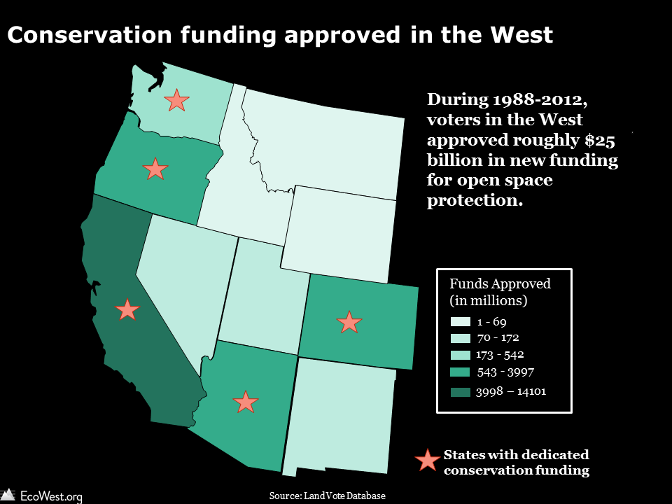
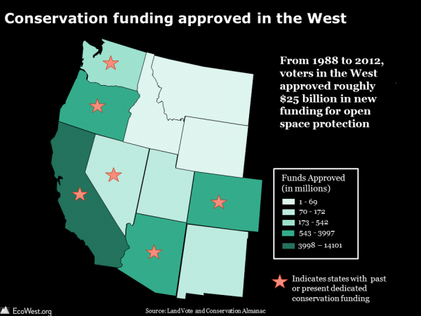
The graphic below, based on TPL’s LandVote database, shows that Western voters approved some $25 billion in conservation funding from 1988 to 2012.

Conservation funding in the West

EcoWest: Given that water is arguably the most precious natural resource in the West, have you observed a link between the public’s willingness to conserve land and their motivation to protect water resources?

Eleanor Morris (TNC): I’m constantly impressed that this connection is instantaneous for Americans. It’s a no-brainer—they intuitively understand, “If I protect this piece of land, then I protect my drinking water.” And this is not a new trend necessarily. Water has always been a huge driving force in conservation finance in the West. It consistently ranks as a top reason in polls as to why people are motivated to pay for land protection

EcoWest: Federal funding programs play a key role in making conservation finance initiatives possible. Have recent financial challenges in D.C. presented any threats to these funding sources?

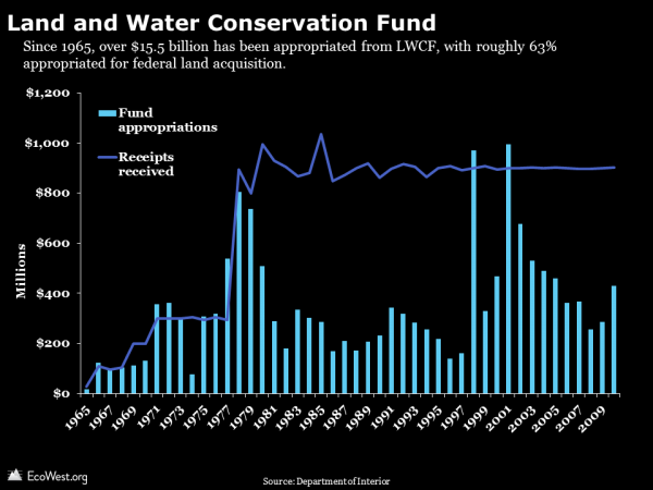
Dee Frankfourth (TPL): The trendline in general for federal funding is definitely of concern. The Land and Water Conservation Fund (LWCF) is slated to end in 2015, since it was initially designed as a 50-year dedicated funding source. TPL and our partners are currently working to build allies in Congress to ensure leadership for either a renewal of this fund or a new source that supplants it. The federal government provides an important value proposition to states: “We’ll give you [the state] 50 percent of funding if you put in the other half for a conservation project.”

The graphic below summarizes LWCF appropriations and receipts. Learn more about how the LWCF works in this report from the Congressional Research Service.

EcoWest LWCF graphic

EcoWest: Eleanor, can you tell us about the Montana Legacy Project, the nation’s largest private conservation purchase? Are there any key lessons learned from TNC’s efforts to protect those 310,000 acres?

Eleanor Morris (TNC): Yes, this project had an innovative and unprecedented funding package from the federal government, Montana state government, and private sources. On-the-ground support from the public was another important feature that made this deal possible. TNC and our partners worked in counties that were already 80 to 90 percent public land. It took concerted effort to work with communities in these counties and discuss how they envision their future land use.

EcoWest: Have you observed a trend of “conservation envy” in your work – where one county creates a dedicated source of conservation funding, and an adjacent county seeks to follow suit?

Dee Frankfourth (TPL): Yes, there is currently a county in southeastern Washington undertaking the process to create a dedicated pot of conservation funding. This is a great example of a county, in a very conservative part of the state, looking next door at Spokane, seeing how they are protecting their parks, open space, and natural areas with a dedicated fund  created  20 years ago, and thinking how it should do the same. After TPL presented to elected officials in the county last March, we performed feasibility research this summer and found that it would cost $11 per household annually (less than $1 per month) to create a dedicated conservation funding source. The next step is to conduct a public opinion survey of registered voters to see if there is sufficient support to warrant moving ahead with a ballot measure.

EcoWest: How might growing concern about fire and drought as threats to local water supplies influence TNC’s work going forward?

Eleanor Morris (TNC): Last year, the City of Flagstaff, Arizona approved a $10 million bond to protect nearly 15,000 acres of forest land outside the city’s limits. This was an important measure showing that voters were willing to tax themselves to protect national forest land for watershed services. TNC is now developing strategies to look at whole watersheds, whole ecosystems, whole landscapes. We’re looking at the entire state of Oregon, and the bulk of the state of New Mexico. The aim is to protect lands beyond the reach of one individual city, in order to safeguard all water resources that might be connected to an area’s water supply.

Editor’s note: The David and Lucile Packard Foundation, which supports EcoWest.org, has funded TPL, TNC, and the Montana Legacy Project, but the foundation does not exert editorial control over this website.

Downloads

EcoWest’s mission is to analyze, visualize, and share data on environmental trends in the North American West. Please subscribe to our RSS feed, opt-in for email updates, follow us on Twitter, or like us on Facebook.
Americans are driving less: the state-by-state story

At the peak of the recession, did you swap your family’s annual summer road trip for a “staycation” or plan errands to reduce your number of car trips? Have you engaged in the semi-competitive practice of hypermiling? If so, you’re far from alone in your quest to reduce your annual mileage behind the wheel, according to a recent report from the U.S. Public Interest Research Group (PIRG).

In the report, “Moving Off the Road: A State-by-State Analysis of the National Decline in Driving,” U.S. PIRG shows that 46 states plus the District of Columbia have experienced a reduction in the average number of driving miles since 2004.

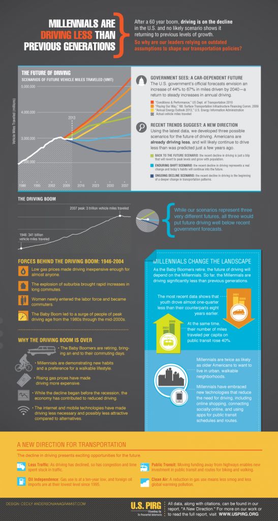
The report counters U.S. government forecasts, which have traditionally held that economic conditions and driving activity are directly related: as the economy improves, driving would be expected to increase. But U.S. PIRG found no correlation between the per capita decline in driving and how states fared economically in recent years. Here’s their summary infographic:

US PIRG new direction infographic
Source: U.S. PIRG

The study puts transportation policy—and the tens of billions of dollars associated with it—in a new light. Joanna Guy, program associate with the Maryland PIRG Foundation, framed the situation this way:

Given these trends, we need to press the reset button on our transportation policy. Just because past transportation investments overwhelmingly went to highway construction doesn’t mean that continues to be the right choice for [the] future.

End of the “driving boom”

During the nearly six-decade “driving boom” that began in 1946, Americans increased their driving nearly every year. Nationally, per capita vehicle-miles traveled (VMT) peaked in the year 2004 and began to decline prior to the recession, which suggests that something other than the economy is behind the drop-off in driving.

In an earlier report released this spring, U.S. PIRG identified a few factors that contributed to the end of the driving boom:

  • The baby boom generation is retiring, leading to far fewer commuting miles.
  • Millennials are driving significantly less than previous generations and prefer a more walkable, public transit-oriented lifestyle.
  • Rising gas prices have increased the cost of driving.
  • The depressed economy has reduced transportation demands for some sectors, even though the driving decline started prior to the recession.
  • New technologies, such as online shopping, have curbed the number of trips to stores, while smartphone apps for public transit schedules have made it easier to incorporate bus and rail trips into one’s lifestyle, particularly in dense urban areas.

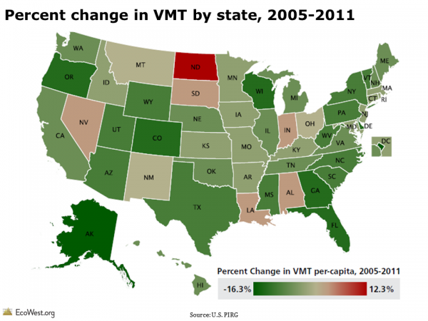
There are only four states (North Dakota, Nevada, Louisiana, and Alabama) where driving miles per capita in 2011 were above their 2004 or 2005 levels. Since 2005, several states—including Alaska, Delaware, Oregon, Georgia, Wyoming, and South Carolina—have actually seen double-digit percent reductions in per capita VMT.

Percent change in vehicle miles traveled (VMT) by state, 2005-2011

State-by-state driving differences

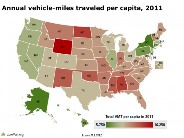
The average American drove roughly 9,500 miles in 2011, but there are big differences in driving patterns at the state level. For instance, the average Wyoming resident drives more than 16,000 miles annually, while District of Columbia residents drive less than 5,775 miles each year. Within the West, the average resident drives around 10,200 miles annually, with Washington State residents reporting the lowest annual figure at 8,300 miles.

Annual vehicle miles traveled per capita, 2011

According to the report, no single factor alone can explain the difference in per capita driving across states. The study examined multiple variables—population density, median household income, frequency of working from home—and found only a rough correlation between more urban populations and lower VMT.

Nationwide, urban residents drive about 9,930 miles per year, while rural residents drive an average of 14,850 miles. Wyoming has the second-lowest population density in the country, so you would expect it to fall on the upper end of the VMT range.

Driving decline: more than an economic aftershock

Although the recent recession has undoubtedly influenced the national per capita decline in driving, U.S. PIRG argues that the trend should not be perceived as a short-lived byproduct of the recession. It cites four reasons:

  • Per capita driving began declining before the recession, with VMT peaking in 2004.
  • Other metrics, such as the percentage of young people with a driver’s license and the number of vehicles per household, also started declining prior to the recession.
  • Per capita driving declined among both the employed and unemployed.
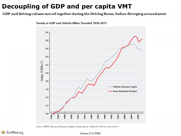
  • Per capita VMT and national GDP moved in tandem throughout the driving boom (1960s to early 2000s). At the beginning of the 21st century, the two indicators decoupled: GDP continued to increase, while driving fell or remained steady.

Decoupling of VMT and GDP

Reimagining future transportation policy

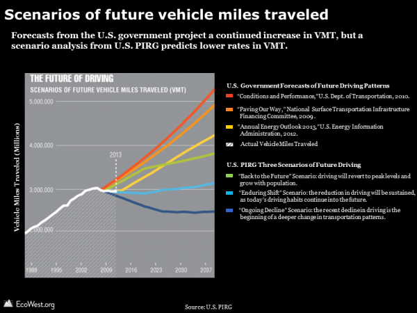
By default, U.S. transportation engineers typically estimate there will be a continually rising number of drivers on the road in the future. A range of government forecasts have all projected a steady increase in annual driving, with the expected increase by 2040 ranging from 44% to 67%.

U.S. PIRG, however, created its own scenarios for the future of driving, all of which predict lower VMT trendlines than government forecasts, as shown in the chart below.

Scenarios of future vehicle miles traveled

The U.S. PIRG report opens the conversation on why and how we might re-envision the country’s transportation policy. In light of tight budgets for transportation projects, there is fierce competition for every dollar. Funds diverted from a potentially superfluous highway expansion could be used to improve alternative transit options, such as bus routes and bike lanes.

Research suggests that investing in alternative forms of transportation is more than a feel-good policy: it can also boost economic development. A study by the University of Vermont Transportation Research Center found that housing prices in Baltimore tended to increase based on the proximity to bicycle lanes.

Data sources

You can download the full report and accompanying data for “Moving Off the Road: A State-by-State Analysis of the National Decline in Driving” from U.S. PIRG here.

The data is also accessible on this dashboard.

Downloads

EcoWest’s mission is to analyze, visualize, and share data on environmental trends in the North American West. Please subscribe to our RSS feed, opt-in for email updates, follow us on Twitter, or like us on Facebook.