All posts by Mitch Tobin

Mitch Tobin, the editor of ecowest.org, is owner of Sea to Snow Consulting and was previously communications director at California Environmental Associates. Prior to joining CEA, Mitch was a newspaper reporter at the Napa Valley Register, Tucson Citizen, and Arizona Daily Star, where he covered water, environmental, and border issues for five years. He was also a contributor to High Country News. Mitch's first book, Endangered (Fulcrum 2010), evaluates the effectiveness of the Endangered Species Act and received a gold medal in the 2011 Independent Publisher Book Awards.

Human footprint maps of Western states and cities

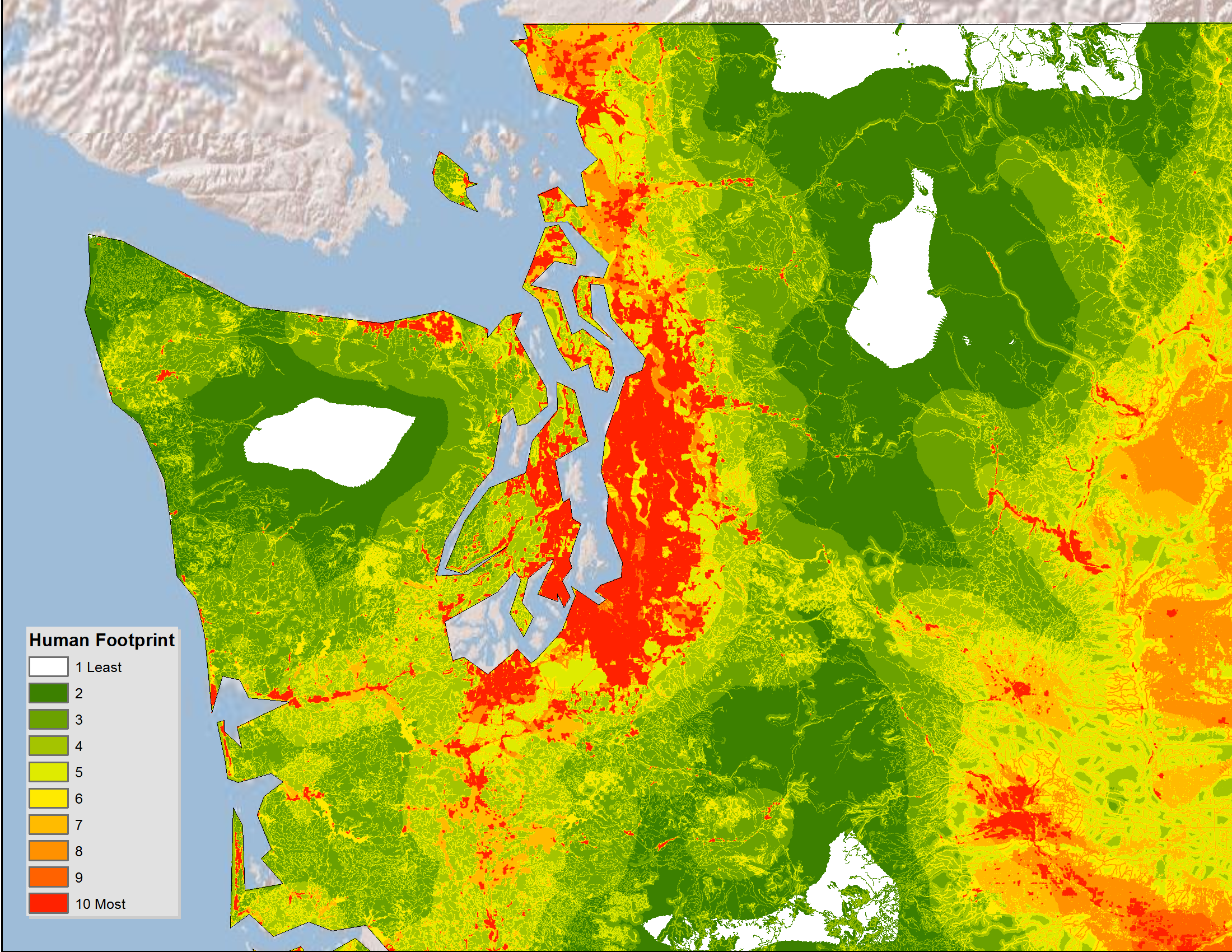
Just a quick post to let you know that I’ve created a gallery of high-resolution maps depicting the human footprint in each of the 11 Western states, plus some major cities in the region.

I wrote about this dataset a few weeks ago and wanted to share some more detailed, zoomed-in views. White indicates areas with the least human impact, followed by green for places where the footprint is minimal, while orange and red areas are where people have done the most to transform native ecosystems.

Below is the gallery, which also available on this page.

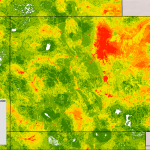
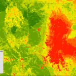
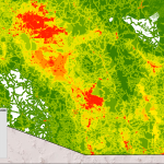
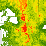
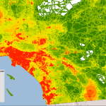
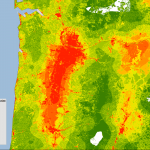
The human footprint map is based on the work of U.S. Geological Survey (USGS) scientists and was the basis of a 2008 paper in Ecological Applications by Matthias Leu, Steven E. Hanser, and Steven T. Knick. The scientists focused on 14 features, including the location of cities, farms, roads, canals, power lines, oil and gas wells, and human-caused wildfires.

Please let me know if you have any issues viewing the maps. This is the first time I’ve used the WordPress gallery feature and I’m wondering if it’s an effective tool for sharing images.

Same goes for anything on EcoWest: as we get off the ground, we’re looking for feedback, suggestions, and other comments from users so we can make this site as useful as possible. Thanks!

EcoWest’s mission is to analyze, visualize, and share data on environmental trends in the North American West. Please subscribe to our RSS feed, opt-in for email updates, follow us on Twitter, or like us on Facebook.

Google Timelapse animates Earth’s changing landscape

Google has just released an interesting tool for tracking environmental changes through satellite imagery.

Timelapse shows changes to the Earth’s surface over nearly three decades, from 1984 to 2012. Each frame in these animations is a year of imagery from the Landsat satellite program.

Google has put together some pre-made views and below I’ve pasted the animations from North America. There’s also a description of each animation in this article in Time.

Las Vegas urban growth

Las Vegas Urban Growth

Wyoming coal mining

Wyoming Coal Mining

Columbia glacier retreat

Columbia Glacier Retreat

I found the Las Vegas view most striking. It’s similar to an animation of the city’s growth that I wrote about here.

What’s really cool about this tool is that you can zoom in to any area on the globe and see how the landscape has been evolving. I focused in on Tucson, where I lived for many years, and I could easily see the growth, especially new golf courses in the desert, as well as the scars left behind by wildfires that struck the nearby Santa Catalina range from 2002 to 2004.

Unfortunately, you can’t zoom in very close with the Timelapse tool, and it doesn’t look like there’s a way to save your own animation. But maybe that’s coming?

I noticed that the Google Earth Engine site also provides an interesting data set on roadless areas that shows places around the globe that are more than 1 kilometer from a road, railway, or navigable river. Below is a screen shot of the dataset, which I’d like to explore further.

Global roadless areas

Google Earth roadless

EcoWest’s mission is to analyze, visualize, and share data on environmental trends in the North American West. Please subscribe to our RSS feed, opt-in for email updates, follow us on Twitter, or like us on Facebook.

Tracking conservation ballot measures

Open space bonds and other ballot measures are a critical source of environmental funding in the United States. Since 1988, American voters have approved 1,810 ballot measures that have generated more than $58 billion for conservation.

These measures usually pass, even though they typically involve increasing taxes and government spending.

To track the success of conservation ballot measures, I’ve created a dashboard on this page based on the Trust for Public Land’s LandVote database. Click on the screenshot below to enlarge.

Ballot measure dashboard

I used the same data to create a couple of slides, which are available for download at the bottom of this post and in this video below.

Conservation measures generally do well at the polls, in part because backers tend to avoid placing them on ballots when the chances of passage are low, such as during a recession. On average, three-quarters are approved, but the number of measures tends to be lower in off-year elections.

In recent years, with the economy in the doldrums, fewer measures have been placed on ballots. Funding peaked in 2008, when some $8 billion was approved.

It’ll be interesting to see whether the number of measures put to voters increases in the years ahead if the economy continues to recover.

Downloads

Data sources

The Trust for Public Land makes this data available through its LandVote database. Data from 1996 onward is most comprehensive. “Measures for the years prior to 1996 have been researched to the extent possible,” the website says, “based on historical research collected from newspaper archives and state and local elections officials.”

EcoWest’s mission is to analyze, visualize, and share data on environmental trends in the North American West. Please subscribe to our RSS feed, opt-in for email updates, follow us on Twitter, or like us on Facebook.