All posts by Mitch Tobin

Mitch Tobin, the editor of ecowest.org, is owner of Sea to Snow Consulting and was previously communications director at California Environmental Associates. Prior to joining CEA, Mitch was a newspaper reporter at the Napa Valley Register, Tucson Citizen, and Arizona Daily Star, where he covered water, environmental, and border issues for five years. He was also a contributor to High Country News. Mitch's first book, Endangered (Fulcrum 2010), evaluates the effectiveness of the Endangered Species Act and received a gold medal in the 2011 Independent Publisher Book Awards.

Video: mountain species, climate change, and the escalator effect

Mountains are especially vulnerable to climate change, so scientists are keeping a close watch on species such as the American pika (Ochotona princeps). This small mammal, which resembles a hamster and is a relative of the rabbit, lives in alpine and subalpine terrain across Western North America.

Although relatively widespread and usually found in protected public lands, the American pika is considered an indicator species for climate change and may face a challenging future. These cute critters are super-sensitive to heat and can die in a matter of hours is exposed to temperatures of 78 degrees or above.

As the mercury continues to rise in the decades ahead, pikas and many other mountain species are expected to ascend in elevation in search of cooler conditions—what’s been dubbed the “escalator effect.” But mountains eventually top out at a summit or ridge, so plants and animals can only climb so high.

“The pika is toast,” is how environmental law expert J.B. Ruhl opened his 2008 Boston University Law Review article on the challenge of administering the Endangered Species Act in an era of climate change.

Although some scientists and conservation groups remain deeply troubled about the pika’s prospects, recent research on the species has suggested it may be more resilient than previously thought.

Because pikas are photogenic and mountains are at the heart of the American West, I thought they would be fitting subjects for our first EcoWest video, which is embedded below (you can also watch on our Vimeo and YouTube channels). This is a new format that we’d like to explore further, so I’d welcome any feedback from viewers.

Escalator effect: climate change and mountains from EcoWest on Vimeo.

Background on boulder bunnies

Pikas live near sea level in parts of Western Canada, but in the United States they’re found much higher up. In places such as Nevada and Southern California, they’re rarely observed below 8,200 feet. In North America, as one moves southward toward warmer climes, pikas live at progressively higher elevations.

Here in Colorado, pikas are a common sight on talus slopes around treeline (roughly 11,000 feet) and above. The five-ounce animals blend in well with the boulders and scree, so you’re likely to hear them chirping first. But they’re not hard to see in summer as they scurry to gather grass and flowers for “hay piles” that will sustain them through the brutal alpine winter.

“Charismatic and conspicuous” is how the National Park Service’s Pikas in Peril project describes the animals, which were called “little chief hares” in the 19th century and are nicknamed “boulder bunnies” today.
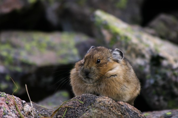
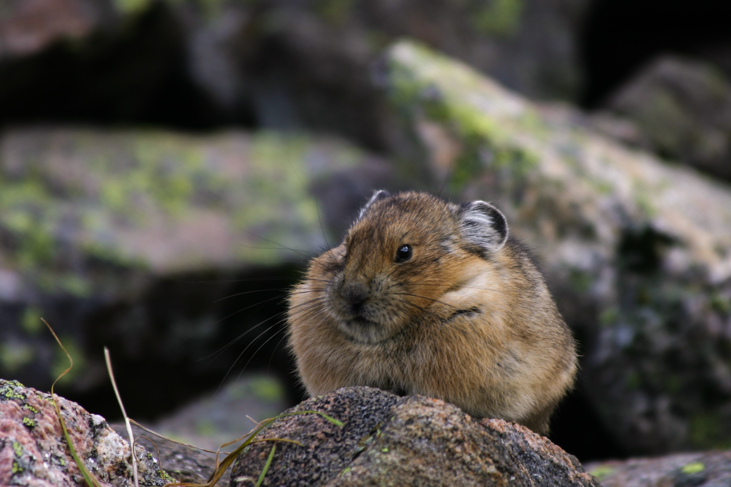
American pika in Colorado
American pika in Indian Peaks Wilderness, Colorado. Photo by Mitch Tobin.

Conservation status and climate change

The International Union for the Conservation of Nature’s Red List, which rates the status of species around the world, puts the American pika in its “least concern” category. But the IUCN also notes that “the most pervasive threat affecting the American pika appears to be contemporary climate change.”

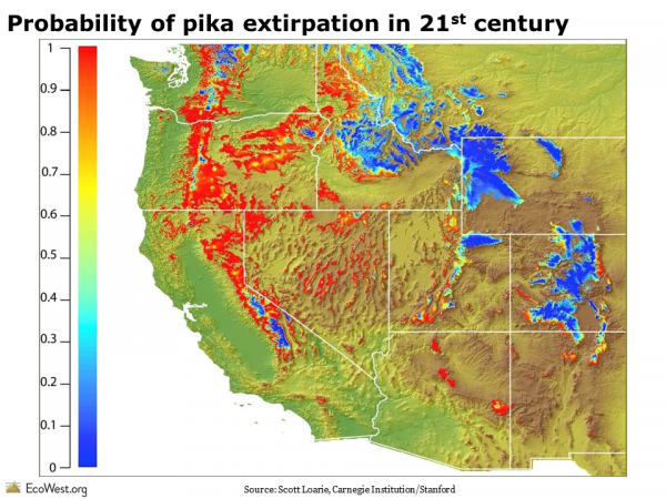
The map below (from this presentation by Scott Loarie at Stanford’s Carnegie Institution) shows the probability of pikas going locally extinct in the American West in the 21st century. Areas in red, such as Northern California, Oregon, and the Great Basin, are where pikas face the greatest threats of extirpation. They’re expected to fare better in higher-elevation blue areas, in places like Colorado, Wyoming, and Montana. (This map includes areas with suitable habitat but no pikas; for the outlines of the pika’s current range, see this image.)

Probability of pika extirpation in 21st century

Noted conservation biologist Stuart Pimm, who taught Loarie in graduate school, says that “if Scott’s map is correct, pikas will no longer be charming companions to weary, out-of-breath hikers like me in Nevada, Oregon, and most of California.”

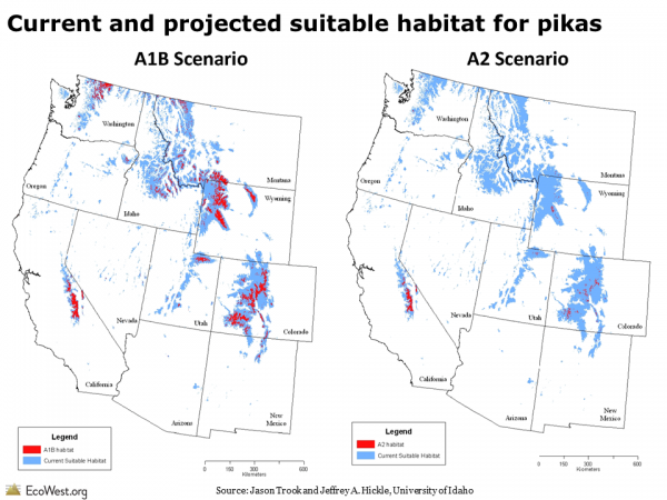
Below is another set of projections from University of Idaho researchers. These maps show the pika’s suitable habitat under three climate change projections: B1 is an optimistic scenario for greenhouse gases, A2 is pessimistic about our ability to contain carbon emissions, and A1B lies in between. According to this study, higher emissions and warmer temperatures will shrink the pika’s range.
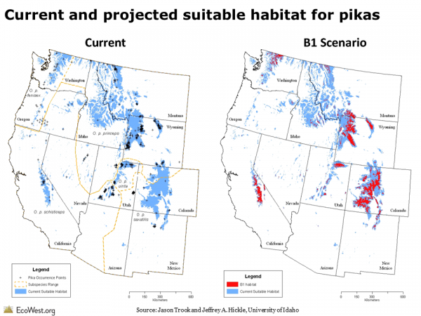
Current and projected suitable habitat for pikas

Current and projected suitable habitat for pikas

Steep declines in Great Basin

Besides increasing heat-related stress, global warming could, paradoxically, cause pikas to freeze to death. If warming temperatures thin the snowpack, the animals will have less insulation during the winter, when they retreat beneath the surface but don’t actually hibernate.

In a place like the Great Basin, where climate change is projected to boost summer temperatures and shrink the winter snowpack, pikas face a “perfect storm,” the IPCC says. A 2011 paper in Global Change Biology concluded that the extinction rate for pikas in the Great Basin had increased nearly five-fold over the past decade. Examining 25 sites with historical records of pikas in the 20th century, the researchers found that nearly half of the local extinctions had occurred since 1999. Pikas in the Great Basin have been moving upslope at an average rate of nearly 500 feet per decade since 1999, 11 times faster than before (see this ScienceDaily story for details).
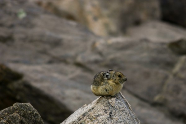
American pika in Indian Peaks Wilderness, Colorado
American pika in Indian Peaks Wilderness, Colorado. Photo by Mitch Tobin.

Resilient species?

While Great Basin pikas appear to be in deep trouble, other research in the American West has found that the species is adapting to the 21st century climate. A 2011 study of 69 historical pika sites in the Southern Rockies, some dating back more than a century, found the animals still present at 65 of the locations.

Since the 1940s, scientists have been observing pikas living in ore dumps near Bodie, California, at about 8,400 feet elevation. “There appears to be no evidence that heat stress in summer at Bodie causes mortality or population decline of pikas on these small habitat islands,” the IUCN said, although warmer temperatures may have inhibited pikas from colonizing unoccupied habitat.

Here’s how the Fish and Wildlife Service describes the situation:

Despite the trends of increasing American pika declines in the Great Basin due to increasing temperatures, there is ample evidence that the species can survive and thrive in some habitats with relatively hot surface temperatures. American pika populations thrive at a lower elevation site in the mountains near Bodie, California and in the hot climates of Craters of the Moon (Idaho) and Lava Beds National Monuments (California). Pika persist at these sites because they reduce activity during hot mid-day temperatures by retreating to significantly cooler conditions under the loose rock areas and perform daily activities during the cooler morning and evening periods. Despite altering their behavior in response to high temperatures, pikas can maintain high birth and low mortality rates.

Feds decline to list pika under ESA

That statement from the Fish and Wildlife Service came in response to a 2007 petition from the Center for Biological Diversity to list the American pika under the Endangered Species Act.

In February 2010, the Fish and Wildlife Service declined to protect the pika under the tough federal law. “Although the American pika could potentially be impacted by climate change, we believe the species as a whole will be able to survive despite higher temperatures in a majority of its range,” the Fish and Wildlife Service said. “We believe the pika will have enough high elevation habitat to ensure its long-term survival.”

Working with the National Oceanic and Atmospheric Administration, the Fish and Wildlife Service developed models to predict if increasing surface temperatures due to climate change would affect the pika (below the surface, in the crevices of a talus slope, temperatures can be as much as 43 degrees cooler).

“New peer-reviewed information and rigorous scientific research demonstrates that the pika is able to survive despite higher temperatures and will have enough suitable high elevation habitat to ensure that it will not face extinction in the forseeable [sic] future,” the agency said. The Center for Biological Diversity called the ruling a “political decision that ignores science and the law.”

The history of the Endangered Species Act certainly has its share of political meddling (see my book Endangered for the full story). But in this case, listing the pika wasn’t a biological slam dunk, in part because the danger lies decades ahead. The Fish and Wildlife Service acknowledged the jeopardy, saying “climate change is a potential threat to the long-term survival of the American pika,” but it concluded that the threat wasn’t urgent enough to warrant regulatory action. About 93 percent of the pika’s habitat is already under federal control and 30 percent is designated as wilderness.

Other species moving uphill

Pikas are just one of many mountain species that are being forced to adapt to climate change by moving uphill.

In August, researchers reported in Ecology and Evolution that plants have been scaling a mountain range near Tucson, Arizona in response to climate change. By re-examining a transect in the Santa Catalina Mountains five decades after a 1963 survey, scientists found “large changes in the elevational ranges of common montane plants” and concluded that “the Southwest is already experiencing a rapid vegetation change.” (See this story from the University of Arizona for more details on the study.)

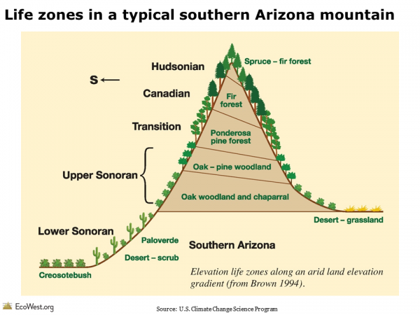
As shown in the figure below, a Southern Arizona mountain is a layer cake of life zones, ranging from the Sonoran Desert at the bottom to a spruce-fir forest at the top. Enough warming could push the top layers right off these mountains.

Life zones in a typical southern Arizona mountain

Mountains and climate change

Anyone who has climbed to the top of West’s tallest mountains knows that biological diversity tends to decline the higher up you go. Here in Colorado, the tundra above treeline is a harsh environment (it’s already snowing in September), so few species can survive. Yet many mountains are biological gems with large numbers of endemic species found nowhere else. “Although species richness decreases with elevation, mountain regions support many different ecosystems and have among the highest species richness globally,” according to the Intergovernmental Panel on Climate Change.

Here’s how the U.S. Global Change Research Program summed up the situation:

Animal and plant species that live in the mountains are among those particularly sensitive to rapid climate change. They include animal species such as the grizzly bear, bighorn sheep, pika, mountain goat, and wolverine. Major changes have already been observed in the pika as previously reported populations have disappeared entirely as climate has warmed over recent decades. One reason mountain species are so vulnerable is that their suitable habitats are being compressed as climatic zones shift upward in elevation. Some species try to shift uphill with the changing climate, but may face constraints related to food, other species present, and so on. In addition, as species move up the mountains, those near the top simply run out of habitat.

In 2010, the Center for Biological Diversity also petitioned the Fish and Wildlife Service to grant Endangered Species Act protections to four other mountaintop species: the ‘i‘iwi, a Hawaiian songbird; the white-tailed ptarmigan, a grouse-like bird that lives in the Rockies; Bicknell’s thrush, a songbird from the Northeast; and the San Bernardino flying squirrel of Southern California. All of these petitions are currently under review.

Winners and losers

On balance, scientists see global warming as a threat to fragile mountain ecosystems, but some montane species may actually benefit from climate change.

In 2010, scientists reported in Nature that yellow-bellied marmots (Marmota flaviventris) had increased in both size and number in response to warming conditions. Warmer weather means less time hibernating, more time fattening up, and therefore a higher survival rate for this type of ground squirrel. “Earlier emergence from hibernation and earlier weaning of young has led to a longer growing season and larger body masses before hibernation,” the scientists concluded. (See this companion story in Nature and segment on NPR for more on the marmot study.)
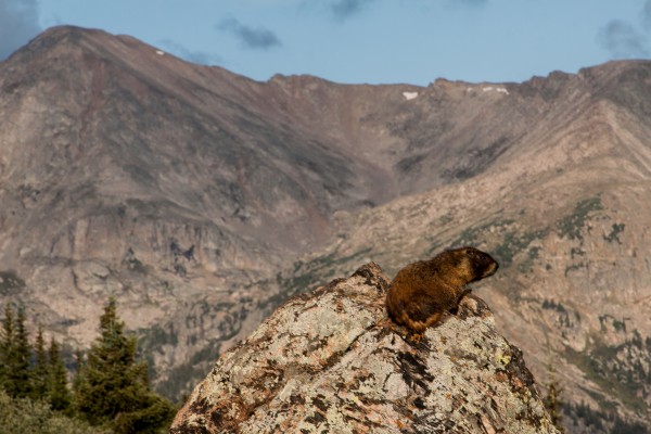
Marmot in Holy Cross Wilderness, Colorado
Marmot in Holy Cross Wilderness, Colorado. Photo by Mitch Tobin.

Climate change will create winners and losers, not only among high-country critters but also in human society and the global economy. A resurgent marmot population will have implications for other species in their habitat, while any declines among pikas will affect their own ecological niche. As challenging as it is to predict the future range and behavior of one species, the situation gets even more complicated once you factor in the many interconnections in the web of life.

Downloads

EcoWest’s mission is to analyze, visualize, and share data on environmental trends in the North American West. Please subscribe to our RSS feed, opt-in for email updates, follow us on Twitter, or like us on Facebook.

Climate context for Colorado floods: heavy precipitation, wildfires are on the rise

The heavy rains and flooding here in Colorado have been off the charts, even prompting the National Weather Service to describe the precipitation as “biblical” in its proportions.

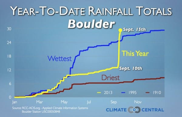
At Discover Magazine, Tom Yulsman reports that areas with the highest rainfall totals have experienced a 1,000-year event–a storm that’s expected to occur once a millennium. Check out this graphic from Climate Central:

Climate Central Boulder rainfall
Source: Climate Central

Because the flooding in Colorado is so extreme and generating so much attention, I wanted to offer some context by sharing some graphics and thoughts. Rain and snow totals jump around from year to year, but there seems to be an increasing trend of very heavy precipitation events in the United States.

What’s more troubling is that scientists are projecting even more deluges (and droughts) in the years and decades to come. Warmer air can hold more moisture, and higher temperatures will be increasing evaporation rates, so researchers are expecting extreme storms like the one in Colorado to become increasingly common as climate change manifests itself in the hydrological cycle.

Add the growing intensity of wildfires in the West, which in recent years have charred many of the watersheds that are now flooding along Colorado’s Front Range, and you have recipe for more costly, deadly disasters. I’ll leave it to scientists to sort out whether there’s any climate change fingerprint in this event, but the projections for the future are worrisome because warming is also expected to intensify wildfire behavior in the West.

Trend toward more deluges

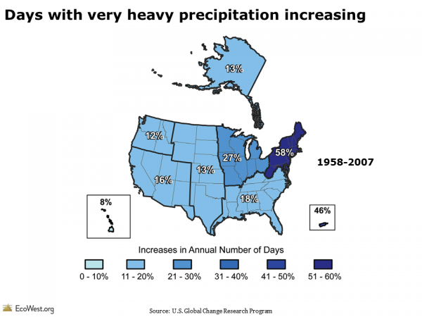
The graphic below, from the U.S. Global Change Research Program, shows the percentage increases from 1958 to 2007 in the number of days with very heavy precipitation, which is defined as the wettest 1 percent of events (the original study is here). The trend has been especially pronounced in the Northeast.

Days with very heavy precipitation increasing

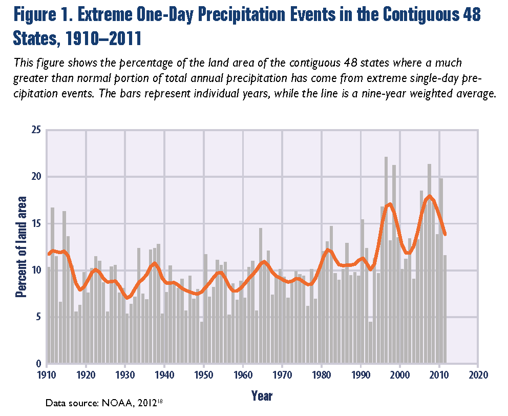
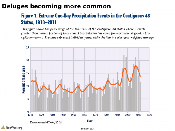
The U.S. Environmental Protection Agency has two interesting charts on heavy rainfall trends. The first one shows that extreme one-day precipitation events have been rising in recent years, but there’s a ton of year-to-year variability. The orange line is a nine-year weighted average. EPA notes that “in recent years, a larger percentage of precipitation has come in the form of intense single-day events.”

Extreme one-day precipitation events

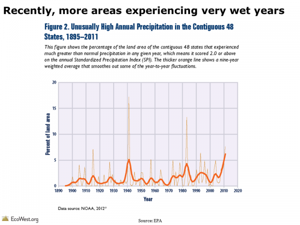
The second graphic shows what percentage of the contiguous 48 has experienced much higher-than-normal precipitation in any given year. The trend is more ambiguous in this chart, but there’s definitely been a spike in recent years.

Unusually high annual precipitationColorado in drought

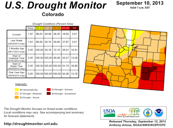
Paradoxically, the torrential rains that we’ve been experiencing in Colorado have come while nearly all of the state is in drought. Below is the latest U.S. Drought Monitor for Colorado. It was released yesterday but based on data through Tuesday. It’ll be interesting to see what this map looks like next week.

Colorado drought monitor

Warming to worsen problem

Looking ahead, we can expect deluges like the one in Colorado to increase in frequency. “Global warming is expected to lead to a large increase in atmospheric water vapor content and to changes in the hydrological cycle, which include an intensification of precipitation extremes,” wrote researchers in this 2009 paper in the Proceedings of the National Academy of Sciences.

Overall, the Southwest and places like the Colorado River Basin are expected to get drier, while the Pacific Northwest is projected to get wetter. Our climate deck , as well as posts on water risk/stress maps and the Colorado River Basin Study, have more on this.

The EPA and Union of Concerned Scientists provide good discussions of the impact of climate change on extreme precipitation events. Flooding causes billions of dollars in damage in the United States annually–in a typical year, it’s the most costly form of extreme weather–so the economic implications of this trend are significant.

In Colorado, the rains are finally letting up in most places and the worst appears to be over. We’ve only received about 3 inches here in Northwest Denver, but that’s actually a whopping total for us. Settlers used to call the western Great Plains the Great American Desert.

The American West has always been a region where residents must navigate between the Scylla and Charybdis of drought and flood, but climate change is making those monsters more menacing. Thankfully, this once-in-a-lifetime storm for parts of the Front Range has only killed a handful of people, but that number could rise. The roar of the Black Hawk helicopter that just buzzed overhead and the stunning images of the flooding are stark reminders that this major disaster will be felt locally for years to come.

Post-fire flooding

There’s also a powerful connection between the worsening wildfire problem in places like Colorado and subsequent flooding, especially during summer, when the North American monsoon taps subtropical moisture and pumps it over the Southwest’s mountainous terrain. Wildfires can incinerate the vegetation that tempers the rainfall and keeps soil in place, thereby dramatically increasing the volume of runoff, sometimes with deadly results downstream. Along the Colorado Front Range, this threat has become a regular feature of the hazardous weather outlook that the National Weather Service publishes.

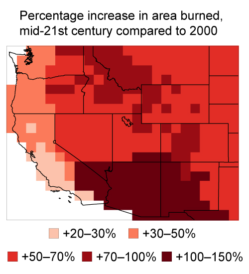
Climate change is expected to dramatically increase the amount of acres burned in the West, as shown in the graphic below from a recent Harvard study, so if business as usual continues with global greenhouse gas emissions, it looks like the ingredients will be in place for many more calamities like the one we’re now witnessing in Colorado.

Percentage increase in area burned
Source: Xu Yue, Harvard School of Engineering and Applied Sciences

Downloads

EcoWest’s mission is to analyze, visualize, and share data on environmental trends in the North American West. Please subscribe to our RSS feed, opt-in for email updates, follow us on Twitter, or like us on Facebook.
The black and blue marble: 10 whole Earth views from space

It’s been called one of the most famous and widely distributed images in human history. The “blue marble,” a 1972 color photograph of the Earth from the Apollo 17 spacecraft, has also been credited with expanding environmental awareness around the globe and highlighting the vulnerability of our home planet.

In the four decades since the blue marble was captured on film, other astronauts and unmanned spacecraft have trained their lenses on the Earth, sometimes while in orbit, other times while racing toward another celestial body. I stumbled upon some of these images while surfing the Web recently and have collected my favorites in a PowerPoint deck that you download at the bottom of this post.

I find these images captivating, even mesmerizing. They’re also useful in creating presentations. NASA’s next generation of blue marble images can be downloaded as very high-resolution files that allow you to zoom in on an area of interest (see our earlier post to learn about similar, high-res images of the Earth’s vegetation).

We often take the 30,000-foot view here at EcoWest, trying to understand mega-trends in the American West, but occasionally it’s worth stepping back even farther, to many millions of miles away, so we can see the truly big picture. Below I describe 10 of the views, including some animations, that I found most striking (click on images to enlarge).

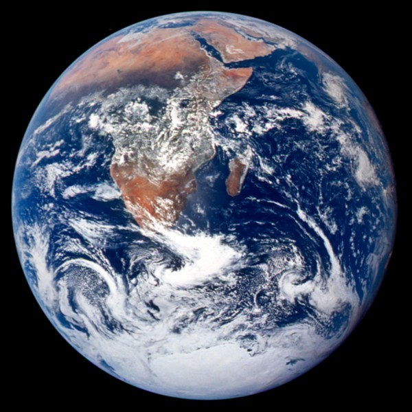
 1) The original blue marble

The iconic blue marble photo was taken on December 7, 1972 as the Apollo 17 spacecraft departed Earth for the moon. The image was snapped 5 hours after liftoff and 2 hours after the spacecraft left its parking orbit around Earth. The spacecraft was already 28,000 miles away from the planet and situated perfectly for the shot–with the sun behind the camera, the full disc of Earth was visible.

Blue marble photo
Source: NASA

2) Earlier color image of full Earth

The blue marble wasn’t the first time the full Earth had been photographed in color. The image below, captured by the ATS-3 communications satellite in 1967, was on the cover of the Whole Earth Catalog in fall 1968.

ATS-3 photo of Earth
Source: Wikipedia

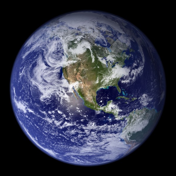
3) Next generation blue marble

NASA’s next generation of blue marble imagery takes advantage of a variety of satellites and stitches together many months of observations to provide a clear view of Earth. Much of the data came from the MODIS device on the Terra and Aqua satellites. Below is the view of the Western hemisphere.

Source: NASA
Source: NASA

Reflecting on the blue marble images, Donald Wuebbles, an atmospheric scientist at the University of Illinois at Urbana-Champaign, described them this way:

The abundance of water on our planet visible in the “Blue  Marble” photo clearly separates us from all others in the solar system. The flows and  interactions of clouds as part of our weather also appear prominently in the photo. The  interconnectedness of all the spheres—hydrosphere, atmosphere, cryosphere, and lithosphere—into one sphere is the power of this image and of later images of the Earthtaken from unmanned spacecraft.

It’s been an epoch since I took Earth science, so I confess to looking up cryosphere (ice caps, glaciers, etc.) and lithosphere (crust and mantle).

 4) Looking down on the arctic

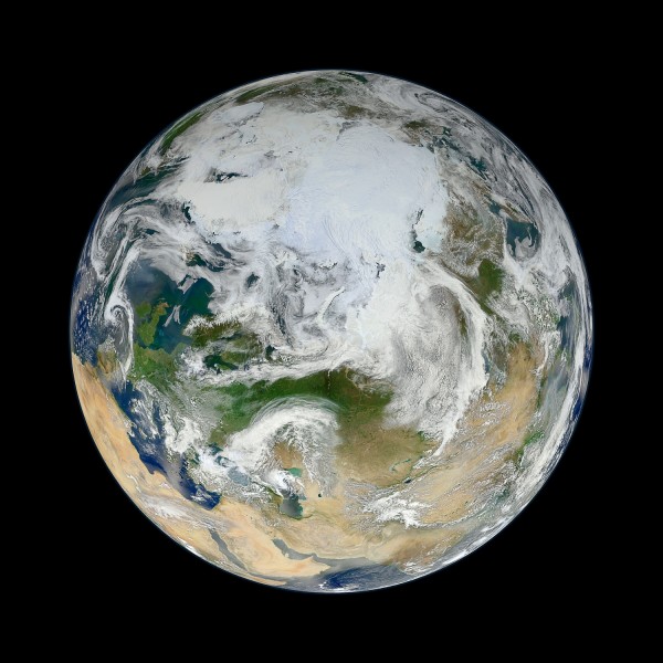
At first glance, you may not recognize the planet depicted below. That’s because you’re looking down on Earth from over Siberia, rather than from the typical equatorial vantage point. In this view of the Arctic, based on 15 passes by the Suomi-NPP satellite on May 26, 2012, you can get a sense of why melting the Greenland Ice Sheet would lead to a cataclysmic rise of sea levels by some 24 feet.

Source: NASA/GSFC/Suomi NPP

5) Night lights and the black marble

The dark side of the Earth has plenty of lights, as shown in the image below from April and May 2012. NASA’s city lights series provides a powerful summary of development patterns across the globe. The PowerPoint deck includes some close-ups of the United States, but even in this hemispheric view you can see how the country’s population is concentrated in the eastern half and along the West Coast.

City lights of North America at night
Source: NASA

6) Animation of Earth’s rotation

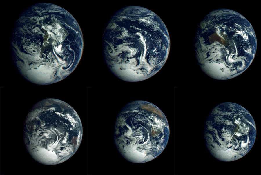
As the Galileo spacecraft departed Earth in 1990 for its exploration of Jupiter, it looked back and captured this sequence of images over a 25-hour period.

Galileo Earth animation
Source: NASA/JPL/Doug Ellison

7) Lunar transit of Earth

The Deep Impact spacecraft, launched in 2005 to study comets, sent back stunning images of the moon transiting the Earth. This animation shows a lunar transit in 2008 from 31 million miles away.

Earth moon animation
Source: NASA/JPL/UMD

8) Solar eclipse viewed from lunar orbiter

The Lunar Reconnaissance Orbiter, launched in 2009, captured the May 12, 2012 solar eclipse in the image below, which shows the shadow over the Aleutian Islands.

Solar eclipse seen from moon
Source: NASA/GSFC/ASU

9) Time-lapse from the International Space Station

OK, so this one’s a little different, but I would urge you to check out the video embedded below, which shows what the Earth looks like to the crew of the International Space Station. There are some spectacular views of the night lights, aurora borealis/australis, and lightning flickering in thunderstorms. The video is a time-lapse compilation of photographs taken by the crew of the space station, which orbits about 260 miles above Earth at 17,200 mph.

Earth from Michael König on Vimeo.

10) The earth and moon from Saturn

Finally, to put things in perspective, there’s this recent view of the Earth from the Cassini spacecraft orbiting Saturn.  From 898 million miles away, our planet is just a dot.

View of Earth from Saturn

More images coming

In the years ahead, I’m sure we’ll be treated to even more stunning images of planet Earth. The Deep Space Climate Observatory, originally proposed by former Vice Preident Al Gore and possibly inspired by the original blue marble photo, is scheduled to be launched in 2015 by the SpaceX company. The observatory, which became a political football, will be situated about 1 million miles from the planet, at a point where the gravitational pull of the Earth and Sun cancel. From there it will warn of potentially harmful solar activity, and have a continuous view of the sunlit side of Earth.

Data sources

The best source I found for whole Earth images is this page on the Planetary Society’s website.

NASA’s blue marble images are found on this page and described further here.

Downloads

EcoWest’s mission is to analyze, visualize, and share data on environmental trends in the North American West. Please subscribe to our RSS feed, opt-in for email updates, follow us on Twitter, or like us on Facebook.